Pathing data determining how units can be placed and moved over. Buildings need footprints to prevent units from walking through them, and for placement.
Hints[ | ]
The footprints have a unique editor UI when modifying
Footprints are stored as triangular geometries with more complex footprints requiring more triangles to form
Custom pathing footprints are bugged and will not initially show up in the editor (as of Mar 03, 2011). In order to preview your footprint in the editors pathing mesh close the Terrain Editor and reopen it.
Footprints forbides units from turning. Only turrets can outpass this issue.
The integration of a footprint in game is poor of possiblities/content. You can put a footprint innate on a unit or a doodad and that's about it. There is no upgrade, behavior (other than Creep Source) that can create footprint content, perhaps only a create unit effect that would create a stationnary dummy unit with predefined footprint. Even Creep Source behaviors are limited to Creep apply, and can't use any other footprint effect. A unit with a footprint inside a transport/inventory/magazine does not generates its effects either.
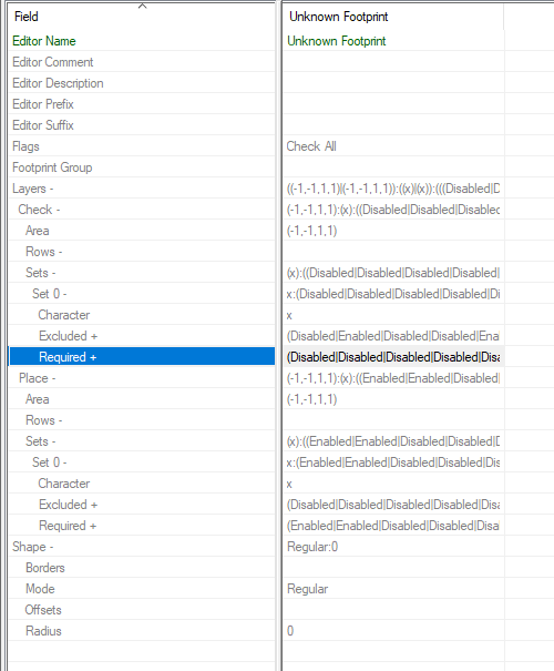
Table view does not offer much settings on spot, it is best opening the layer field to get the window as seen below, which posses most relevant modifications.
To understand this type of data, one must understand the main parts of this screenshot. The bold names can be directly be refered to the image above.
The square in the center is the Area field of this data. You can paint it with variety of set ups and there are mainly 3 categories (Layer). Each category has its own square, which means that painting one of them will not affect what the other layers currently have.
Pathing: The active pathing of the unit. This marks and tells how many squares the unit/structure is currently using, especially if you are to build another structure around.
Placement Apply (said as Place on Table View): Determines what placement flags are applied to cells; The effect caused on surrounding terrain/units once the footprint is active. Ex: Generates Creep, Uncreeps, Blocks Vision, etc. This could also be used for creating shrubs (hiding spots in which ground units cannot see from the outside, but insiders can see from it).
Placement Check (said as Check on Table View): Determines placement flag requirements for cells when a unit with this footprint is being placed
The Placement Apply and Check both have their Sets. Each sets represent a variety of flags that can be modified using the the Define Set button (seen in Excluded and Required on table view). The flags purposes are unique to the layer type. The None selection only means "do not use/modify any of those". It is not mandatory to use every set, as only one could do, but it is possible to use up to 4 sets to create variety in the footprint. Just take note that according the flags checked, the color of the square painted by the selected set can change in various colors, based on those flags.
Fields Description[ | ]
Flags[ | ]
Check All: (Unknown)
Footprint Group[ | ]
Used for classification of footprints
None: (Unknown)
Generic: (Unknown)
Shapes: (Unknown)
Shapes\Contours: (Unknown)
Shapes\Tiles: (Unknown)
Specific: Unique Footprints used for a specific unit/doodad
Specific\Doodads: (Unknown)
Specific\Others: (Unknown)
Specific\Structures: (Unknown)
Layers - Area[ | ]
Determines the size of the footprint area for the pathing and placement relative to the unit/doodad origin
Automatically calculated by the Footprint Editor
Layers - Rows[ | ]
The arrays for the placement apply and placement check maps for the footprint
The left is placement check and the right is placement apply
Layers - Sets - Character[ | ]
The symbols used for the set numbers on the placement maps for the footprint
Period (.) = (None)
x = Set One
o = Set Two
f = Set Three
m = Set Four
Layers - Sets - Excluded[ | ]
Flags for the placement check and placement apply Invalid conditions for each Set
Although available for placement apply they are not used by the footprint editor
No.1 = Ground - No Spawn
No.2 = No Build
No.3 = Near Resources
No.4 = Resource Drop Off
No,5 = Creep
No.6 = No Creep
No.7 = No Creep Permanent
No.8 = Masked
No.9 = Fogged
No.10 = Block Vision
No.11 = Boost Cliff
No.12 = Boost Height
No.13 = Shrub Vision
No.14 = No Burrowing
No.15 = No Can See
Layers - Sets - Required[ | ]
Flags for the placement check and placement apply Required and Acts As conditions for each Set
No.1 = Ground - No Spawn
No.2 = No Build
No.3 = Near Resources
No.4 = Resource Drop Off
No.5 = Creep
No.6 = No Creep
No.7 = No Creep Permanent
No.8 = Masked
No.9 = Fogged
No.10 = Block Vision
No.11 = Boost Cliff
No.12 = Boost Height
No.13 = Shrub Vision
No.14 = No Burrowing
No.15 = No Can See
Shape - Borders[ | ]
Used to determine the shape of the pathing layer
Automatically calculated by the Footprint Editor
First digit appears to be some point index number
Third digit is the pathing value/type
0 = Unpathable Terrain
1 = Ground
2 = Building
3 = Cliff
Shape - Mode[ | ]
The pathing footprint priority for rewriting the pathing mesh
Known as Type in the Footprint Editor
Regular/Standard: Able to overwrite Ground pathing
Use for structures
Overlay: Able to overwrite all pathing except ground. Unable to create ground pathing over unpathable terrain
Persistent: Permanently overwrites the pathing mesh even on unit death/removal.
Use for Bridges
It is advisable to have units that use this kind of footprint morph into a form that has a persistent a footprint that restores the pathing grid to its original state before death/removal of the unit
Known to cause cumulative leaks/lag if changed too frequently
Shape - Offsets[ | ]
Location of the points used to create the pathing mesh for the footprint
The number relates to the "Complexity" of the footprint
Automatically calculated by the Footprint Editor
Footprint Editor[ | ]
Complexity[ | ]
Related to the number of triangles needed to make the footprint
Has a cap to reduce potential lag caused by the number of calculations needed to change the pathing mesh/unit pathing
Size[ | ]
How many Terrain Editor placement grid squares the footprint covers
Units are always centered in the middle (small yellow dot)
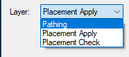
Layer[ | ]
Footprints have 3 layers: Pathing (affects unit pathing), Placement Apply (determines what placement flags are applied to cells), and Placement Check (determines placement flag requirements for cells when a unit with this footprint is being placed)
Resolution[ | ]
Adjusts the resolution of footprints with each setting increasing the resolution by the power of 2
Large: Same scale as the map placement grid
Medium: 1/4 scale
Small: 1/16 scale
Tiny: 1/64 scale
Useful if the map maker wants to maximize utility of map size by scale reduction
Changing to a higher resolution will result in being able to make more detailed and meticulous pathing
Value[ | ]
Nothing: Works as an eraser and removes pathing already placed. Grey in color.
Building: This portion of terrain is unbuildable but still able to be pathed by ground units. Yellow in colour.
Unpathable: This portion of terrain is unable to be moved on by units with ground based movers. Red in colour
Ground: This portion of terrain is considered as part of the ground and can be walked on. Green in colour
Cliff: This portion of terrain is a cliff and can only be traversed by flying units or units with a Scaler mover. Blue in colour
Brush Size[ | ]
Changes how much or how little the cursor paints the selected pathing on the footprint.
Resolution based
Type[ | ]
Standard: Standard footprints are used for most units and buildings. They can only change pathing from ground on the same cliff level.
Overlay: Overlay footprints will overwrite all non-ground pathing. They are rarely used.
Persistent: Persistent footprints will permanently stamp the pathing mesh with its image. They can be overridden but never removed. Use this for bridges.
Not removed on unit death/removal
Needs a footprint of the same type to revert the pathing mesh back to the original on unit death/removal
Placement Apply[ | ]
Placement flags applied to the surrounding terrain around units/doodads with this footprint
Every Set except Set One needs to be defined using the Define Sets button before painting
Each tile can only have one set so factor in flag overlap in designing the footprint
Block Vision: Prevents units being able to see across the footprint if on the same UI: Height as the unit/doodad with this footprint or lower
Boost Cliff: Cells flagged as Boost Cliff will adjust the cliff level to match the value used by the object placing the footprint.
Boost Height: (Unknown)
Creep: If used by a Creep Source behaviour will generate creep in the designated area
Ground - No Spawn: Prevents abilities, behaviours and effects from creating units in the designated area
Near Resources: Used by the Invalid flags of the Placement Check layers of Resource Drop Off unit footprints to prevent placement too close to technology resources eg. minerals
No Build: Prevents building on the designated tiles
No Burrowing: Prevents (not sure) morphing on the designated tiles
No Can See: Prevents the area from being revealed by any means.
No Creep: Instantly removes creep on the designated tiles.
No Creep Permanent: Instantly removes creep on the designated tiles and prevents creep growth even after death/removal of the unit/doodad
Resource Drop Off: If larger than the Movement: Radius of the unit with this footprint, the proximity of this layer of the footprint will be used for technology resource drop off by units using a Harvest ability
Shrub Vision: Blocks ground vision sight of line if the unit is not inside the shrub flagged terrain. Used by Shrub doodads like Vents & Shrub Foliage.
Placement Check[ | ]
Determines placement flag requirements for cells when a unit with this footprint is being placed.
Every Set except Set One needs to be specified before painting
Required = must have and Invalid = cannot have
Same flags as Placement Apply except the following:
Fogged: Is the terrain visible or hidden by fog of war


